
Howdy all. Well, this is the story of how I almost climbed the Santa Ana Volcano, the Volcan de Santa Ana, back in April this year. I’ll try and talk a bit about logistics too. I was there with Graham and the good news is that although I did not make it to the top of the volcano, Graham did and in the video I will include in this post there is a little bit from the top shot by Graham.
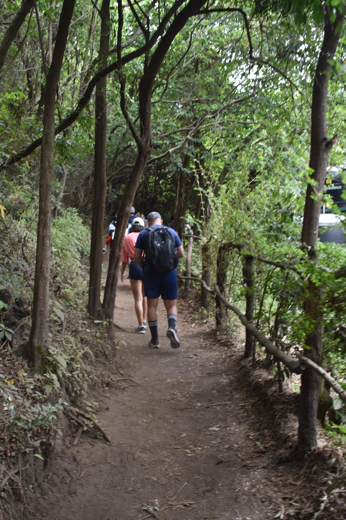
So let’s start with what happened to me. I got to the start of the hike. We joined a guide and a fairly large group of 30 or so hikers, and we made our way up the pretty decent but steep path. There are fees I will go over too, park entrance fee and a fee for the guide. I really don’t know how far I got up before I had to call it a day. The peak is 2,381 metres above sea level, so I guess the hike starts at a bit over 2,000 metres. Altitude can affect you from 1,500 metres I am reading as I write this. I’ve hiked as high as 4,000 metres before, and I’m not going to lie, it affected me then too but not like this.

Add into the mix I hiked 4,000 metres in 2009, much younger, MUCH thinner and MUCH fitter, I guess I shouldn’t feel as bad as I did about not making it. But it was very disappointing. I hiked for hours looking for gorillas in Uganda without issue. Anyways I think I made it half way maybe a fraction more from the trailhead before I turned back. I was struggling to draw in breath and I couldn’t keep the pace up. If I was in a small group and we had more time, I think eventually I would have got there, but they were on a tight schedule and had to return by a certain time.
The path was steepish, but as I said a decent path, but Graham did say that although many people claim it’s an easy hike, it was harder than he had expected and it’s not for those without a decent level of fitness.
So anyway, to get there from Santa Ana many people take a bus that is scheduled to leave Santa Ana at around 730 – 745am. It gets to the trailhead area around a place called ‘El Tibet’ which I think is a guesthouse. The bus is the number 248. It’s around a dollar one way, but we went with an Uber which was around $15-20USD for the convenience and we would have arrived before 9am I would say. Just down from the El Tibet is the trailhead entrance with a couple of food stalls for you as you wait where you can buy pupusas, a sort of pancake pocket made out of corn with fillings of meat, beans and/or cheese which are rarely more than 50 cents.
We waited for a while for the guides to arrive and then for other hikers to come and then were separated into various groups around 1030 – 1045am. We would have liked to have left earlier but generally I don’t think you can go without a guide. If you wanted to in Santa organise a private tour then you would have your own guide and you could start the hike much earlier, meaning you could take your time. Which would have helped me a lot.
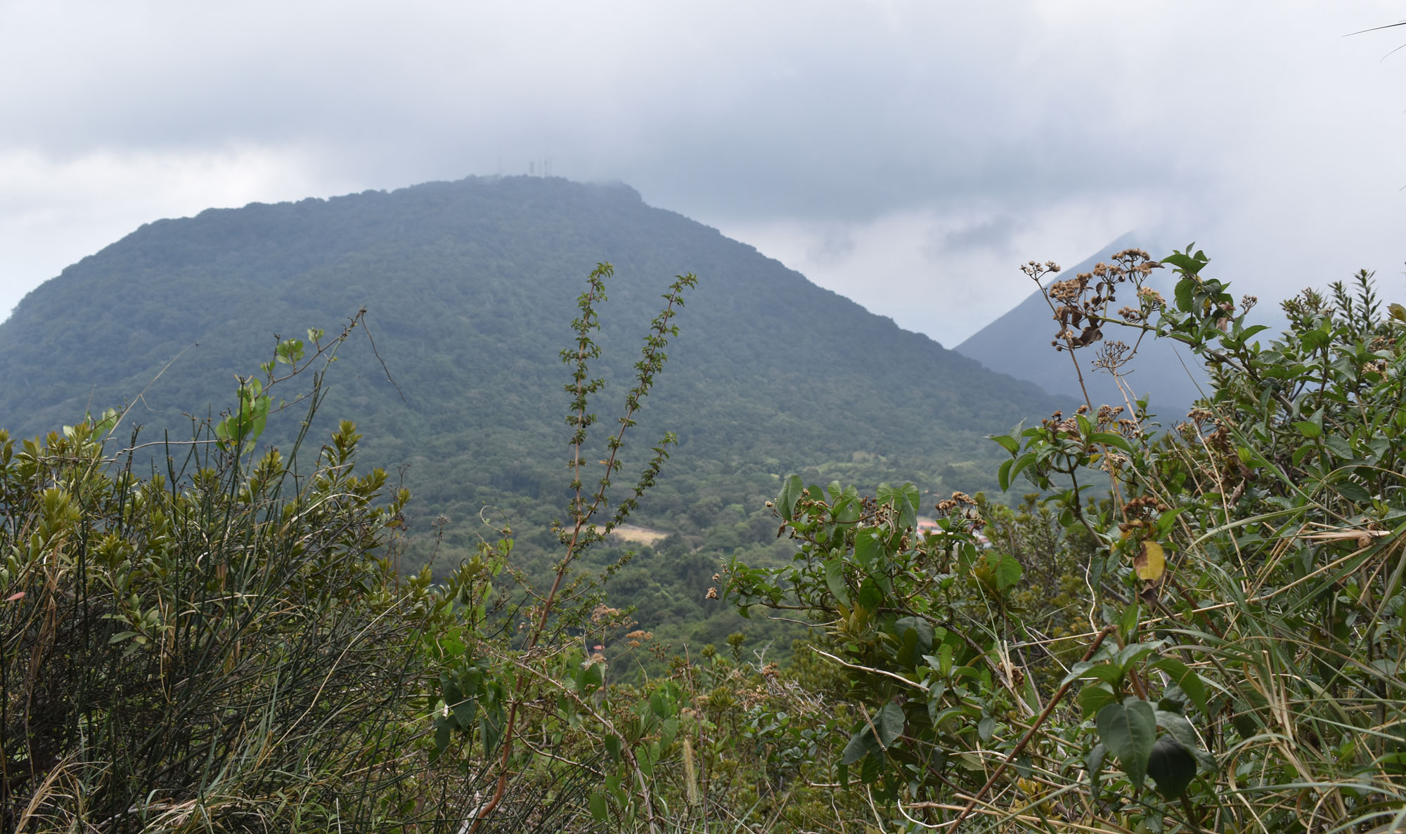

Park fees were $3USD and we paid our guide $4USD, so if you were to take the bus you really wouldn’t spend much on the day, although that doesn’t include a tip which is expected. I hiked for over an hour, and a bit of a way up there was this tower with lookout platforms up stairs and ladders. From here I got a bit of a view of Lake Coatepeque, through the clouds that were passing over. At times I looked up and saw what I think was the peak of the Volcan de Santa Ana.
Graham got up there and the crater is quite beautiful from the shots I have seen from Graham and online, but I have to say the cloud on the day we went obscured a lot. It made it quite atmospheric, but impossible to get wide, clear shots.
Sadly one of the guides (our group had two) responded to my struggles frankly by bullying me repeatedly. Perhaps the idea was that I would respond by finding an inner strength, but it didn’t work and left a sour taste in my mouth, he kept berating me and telling me I was letting everyone down. Anyways, I can take it but it rightly pissed me off pardon my French.
After turning around I did manage to climb the tower for the lookout views and made my way down to the car park/trailhead. It was a long wait for Graham, and we missed the 115pm 248 bus back to Santa Ana. The next was at 4 or 430pm, we were resigned to waiting for it because the reception was poor for our phones and there didn’t seem to be any Ubers on the mountain. However, someone was coming up the mountain finally and we got accepted in a few seconds of phone reception. We lost connection and didn’t know where the car was but somehow he found us and returned us to Santa Ana.
So do I recommend it? Well, yes I do but just be aware that you need to be fitter than I was (I say that after losing over 10kg since April). Do I think I could do it today? Not if the altitude affected me I guess sadly. But maybe one day I will be fit enough again. Later in Central America I would get to the top of a couple of volcanoes, which was gratifying but none by such a challenging hike. So be aware the trail is pretty much uphill all the way. You don’t need to be an advanced hiker by any means, but be prepared for changes in weather, possible affects of altitude and that the big groups move quickly and don’t have much in the way of stopping to get your breath. Thanks for popping by! May the Journey Never End!

Still a wonderful experience.
Bad guide, you did your best. Hiking and high altitudes are tricky, it wasn’t meant to be this time Andy. Don’t feel bad about it
Too bad, when we were there it was very cloudy and we almost didn’t go, but after a little wait at the top, the clouds lifted for about 3 minutes so we could see the crater. But you really didn’t miss much, it’s not a spectacular volcano. Maggie
Altitude is definitely tough! I’m a decent hiker but it takes a toll on me every time, you just never know your body will respond to it. Don’t feel bad about it! Sucks that you had a bad guide